This was February 2007 | « January 2007 | Main | March 2007 »
Upper stage breakup in space
Posted on Tuesday, February 27, 2007
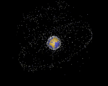
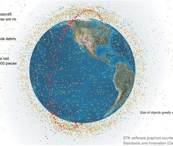
After hearing about it at the ISU symposium last friday, I am reminded about a new breakup in space, this time an unintended breakup of a Russian Breeze-M upper stage. BBC has the story. I wonder whether when we will see a Google Earth version this time...
traceroute Rosetta
Posted on Tuesday, February 27, 2007

Related to my previous post on Rosetta's view of Mars, I just read on Slashdot about the plan Vint Cerf is working on to expand the Internet into the Solar System:
Communication between a rover operator on Earth and a rover on Mars, via a relay orbiter, can't use standard Internet protocols end-to-end. That problem is at the root of a lot of the design work we're doing for the IPN... As part of the NASA Mars mission programme, the project aims to have by 2008 a well-functioning Earth-Mars network.An excellent read I must say, the Slashdot discussion, especially because only at the very bottom of the page does it actually start talking sense, the rest is just geeks getting off on geekjokes. Thought this one was quite to the point:
Parts of this planet we live on don't even have access to a broadband Internet connection, and now they want to plug Mars on the network? Talk about priorities...But then again:
parts of this planet are even more worthless than the lifeless Mars. Leave the stragglers behind..keep pushing forward. -they don't call it the human race for nothing
The idea to expand IP into the Solar System has been around for a while, and to me it obviously makes perfect sense. Evolution you might say. It has been working in Low Earth Orbit onboard an SSTL satellite for quite a while already (video @ Cisco), and Cisco is seriously interested to get deeper into the game.
Rosetta's view on Mars
Posted on Monday, February 26, 2007
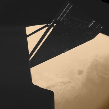
Click to enlarge
Quite an exquisite image! Biggest impression: hardly any atmosphere. Makes it feel very sterile, artificial almost, as if it was surrounded by the blackness of virtual space...digital darkness.
More about Rosetta's flyby of Mars at the European Space Agency.
KML search capability: hurricane+katrina
Posted on Tuesday, February 20, 2007
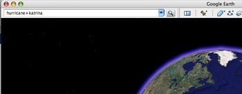
Click to enlarge
OgleEarth and Directions Magazine have the news of a KML search capability recently announced by Google on their maps API blog.
Leaving the discussion on the licensing of Google Earth @ work for a moment, here is an intruiging thought I like from Allen Doyle discussing the release:
But, hey! It's a start. The buzz is there. It's easy to post KML files. How hard would it be to post the entire metadata holdings of a large geospatial data provider like NASA or NOAA in KML? I bet a service like GCMD could post theirs in a week. At Where 2.0, we could be watching demos of Google Earth finding, and displaying, realtime remote sensing data.Makes me wonder what an HTM would have to say about the patterns?
Btw, below is what Google Earth now comes up with searching for 'hurricane+katrina'. Fairfield Inn by Marriot? Not exactly what I was looking for...although...mmm, maybe...if it were realtime data ;)
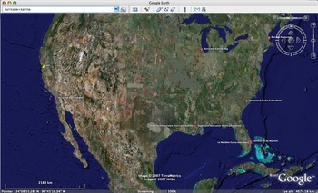
Click to enlarge
Mars rovers on Earth
Posted on Tuesday, February 20, 2007
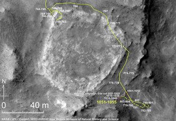
Click to enlarge
Thinking about a project by c5 I read about in Jeremy Hight's text on Floating Points:
Now groups such as the C5 collective are doing work such as the GPS mapping of the entire great wall of china and then placing the coordinates in another location. This type of work creates a layered commentary and plays with form and semiotics as well as referencing the Situationists who developed absurd commentaries like a walk through the streets of Paris following a map of another city.
I had an idea: lets digitally translate the trajectories of the 2 Mars rovers to a suitable location on (Google) Earth.
On Intelligence
Posted on Sunday, February 18, 2007

Every now and then I gather a list of books I come across while doing research on the Net and order them via Amazon. The latest batch included a book called 'On Intelligence' by Jeff Hawkins, published in autumn 2004 (Amazon). I started to read it a couple of days ago and it completely captured my imagination. Finished it in 3 reads. If you are interested in state-of-the-art thinking on how the brain conjures up something like intelligence, and how this could potentially be implemented in machines, this is it.
Some of the most thought provoking points for me stem from his discussion on the potential of an Artificial Intelligence (AI) intelligent machine, or HTM (Hierarchical Temporal Memory) as he calls his model (.ppt), to make sense of the world through some as yet undefined exotic senses. For example, if he is right that the neocortex basically works on patterns, an intelligent machine based on HTM can learn to make sense of (and predict) global weather patterns using as exotic sense a widely distributed sensor web. Basically, any pattern can be used in this sense, be it Google user statistics, stock market fluctuations, satellites studying Solar Weather, genetic sequencing, hell, even the web itself is probably one big pattern if you have the right senses for it...we could be in for some pretty unexpected extensions of our reality, if we know how to translate them back to our human senses that is...
Doing some further background reading, I came across a couple of interesting video presentations by Jeff on his theory, potential applications and his future plans. In addition, I found this remarkably recent (feb '07) Business2.0 article on his current whereabouts at Numenta, the for-profit company he spun off from the Redwood Center for Theoretical Neuroscience to implement the model he described in his book 2 years ago. And here is a recent Science article about the same topic (Oct. '06).
- Jeff Hawkins presentation at the 2005 MIT Emerging Technologies conference (48 min.)
- Jeff Hawkins presentation 'How the cortex works' (Sep. '05, 54 min.)
- Jeff Hawkins presentation at IBM Almaden Institute (May '06, 64 min.)
- Business2.0 blogpost with brief video interview
Perspectives
Posted on Sunday, February 18, 2007
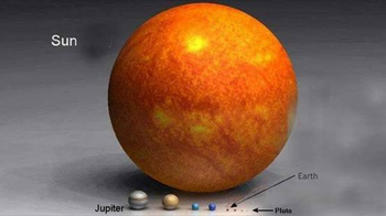
Haven't fact-checked it, but assuming its correct, these are some useful perspectives ;)
Chinese ASAT test analysis in Google Earth
Posted on Sunday, February 18, 2007
Click to enlarge
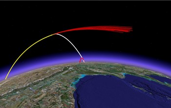
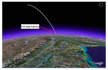
Catching up on my blog role after a week of virtually no second life activities (is that proper English?), I come across a post at OgleEarth on the Chinese Anti-Satellite test I blogged about last month. Turns out researchers at MIT's Science, Technology and Global Security Working Group did exactly what I was looking for: a visualisation of the satellite kill in Google Earth.
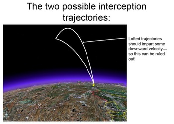
Apart from the kml file displaying above scene in Google Earth (which as yet appears to be a static visualisation only), they also issued a report on the same website which gives some further analysis of the event. It is here that I am happy to find the first (well, actually 2nd ;-) online evidence of the use of Google Earth for actual visualisation in the realm of space engineering and analysis beyond mere pretty images (see images at bottom of this post).
Scanning through the document, it seems the program they made the analysis with is a recently released stand-alone program to calculate ballistic missile trajectories which has a direct output to Google Earth. From their website:
GUI_Missile_Flyout is a stand-alone program running under Windows for simulating ballistic missiles with 1, 2, or 3 stages in a framework with a round, rotating Earth. Users can easily input all the necessary parameters in an intuitive graphical user interface (GUI). A modest number of quantities can be interactively plotted on the Interface but the complete trajectory can be saved as either an Excel or Matlab file for further analysis. The trajectory can also be directly displayed in Google Earth for visualization. The GUI can be used to optimize gravity turn parameters to maximize range or aim at a specific target (entered, as is the launch site) through latitude-longitude pairs. In addition to an introduction to using the program, this paper describes the integration of the three-degrees-of-freedom equations of motion and approximations made to the aerodynamic (such as a parameterized drag coefficient, Cd).Incorporating the option to directly output to Google Earth readible format is something that has been occuring on a frequent basis in the traditional GIS field but I haven't heard of it yet in the space arena. I wonder for example what STK's strategy is in this respect? They have their own AGI viewer, but as with all the different GIS viewers, who is interested to have all these different systems installed when Google Earth can handle them all at once, and on top of that is also cross-platform (which most sophisticated analysis tools are certainly not yet).
If you use this program for a publication, please reference: Geoffrey Forden, “GUI_Missile_Flyout: A General Program for Simulating Ballistic Missiles”, submitted to Science and Global Security. December 2006.
Click to enlarge
Click to enlarge
Nature's own GPS satellites
Posted on Sunday, February 11, 2007
Click to enlarge
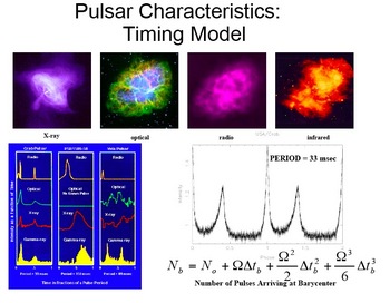
Doing some research for a project I am collaborating on with Jeremy Hight, I just learned about DARPA's X-Ray Pulsar-based Navigation and Timing (XNAV) project, a likely candidate for future space navigation beyond the GPS/Galileo web. Seems the whole Solar System will become a location aware arena in the not too far future...
For a good intro, have a look at this DARPA project powerpoint. Some more information can be found at NewScientist (Sep. '06), and The Space Review (Dec. '06).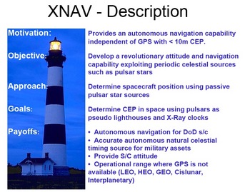
Click to enlarge
The Space Economy
Posted on Friday, February 9, 2007
Click to enlarge
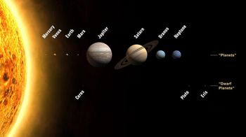
How to market a +30 year product/programme like the US Vision for Space Exploration (VSE)? Luckily for us some folks over at NASA are thinking about it:
“As I see it, questions about the Vision boil down to whether we want to incorporate the Solar System in our economic sphere, or not. …The ultimate goal is not to impress others, or merely to explore our planetary system, but to use accessible space for the benefit of humankind.”
Dr. John Marburger
The President’s Science Advisor
Speech to the 44th Robert H. Goddard Memorial Symposium
March 15, 2006

Click to enlarge
Google is coming to town
Posted on Friday, February 9, 2007

Well, not exactly Amsterdam, but the Netherlands at least: Google opens datacenter at Eemshaven (near Groningen) (in Dutch).
Bill Hicks on recursion by marketing
Posted on Friday, February 9, 2007
Recursion (as discussed in this presentation by Kevin Kelly) according to Bill Hicks, taken from this wikipedia entry on him (youtube):
By the way, if anyone here is in advertising or marketing, kill yourself.
Just a little thought. I'm just trying to plant seeds. Maybe one day, they'll take root. I don't know. You try. You do what you can. Kill yourself.
Seriously, though. If you are, do. No, really. There's no rationalisation for what you do, and you are Satan's little helpers, okay? Kill yourself. Seriously. You are the ruiner of all things good, seriously. No, this is not a joke, if you're going: "There's going to be a joke coming." There's no fucking joke coming. You are Satan's spawn, filling the world with bile and garbage. You are fucked, and you are fucking us. Kill yourself, it's the only way to save your fucking soul. Kill yourself. Planting seeds.
I know all the marketing people are going: "He's doing a joke." There's no joke here whatsoever. Suck a tail-pipe, fucking hang yourself, borrow a gun from a Yank friend – I don't care how you do it. Rid the world of your evil fucking machinations. I know what all the marketing people are thinking right now too. "Oh, you know what Bill's doing? He's going for that anti-marketing dollar. That's a good market, he's very smart." Oh man. I am not doing that, you fucking evil scumbags! "Oh, you know what Bill's doing now? He's going for the righteous indignation dollar. That's a big dollar. Lot of people are feeling that indignation, we've done research. Huge market. He's doing a good thing." God damn it, I'm not doing that, you scumbags. Quit putting a goddamn dollar sign on every fucking thing on this planet! "Oh, the anger dollar. Huge. Huge in times of recession. Giant market, Bill's very bright to do that." God, I'm just caught in a fucking web. "Oh, the trapped dollar. Big dollar, huge dollar. Good market, look at our research. We see that many people feel trapped. If we play to that and then separate them into the trapped dollar …"
YES2 AIT @ ESTEC
Posted on Friday, February 9, 2007

Delta-Utec, the company I have been working with the last couple of years, recently moved its whole Leiden office to ESA's research facility ESTEC in Noordwijk, The Netherlands. The whole YES2 team of students, Young Graduate Trainees and Delta-Utec staff are at ESTEC to succesfully complete the final Assembly, Integration and Testing (AIT) of the YES2 satellite before it is integrated on the Foton-M3 platform and launched later this year on a Russian Soyuz. I have been spending the last couple of days in this highly inspirational environment, working on the follow up of the YES2 mission, working title 'Polyspheres'. Here are some of my impressions sofar.
Here we go: locative media branding
Posted on Thursday, February 8, 2007
"The advent of Internet-based flight tracking technology enables an entirely new kind of skywriting. Gulfstream Aerospace sent up one of their $50M business jets today on an 8.5-hour test flight spanning 11 states for the sole purpose of leaving their mark on the Net in the form of a flight track that spells out 'GV' (the nickname of the Gulfstream V aircraft being flown) when viewed online."(via MIT's Advertising Lab blog)
On a similar note, at BoingBoing: Radar of corporate jets leaving the Superbowl

I hope we get to see some of this in space as well, before its too late...
You, Science and Recursion
Posted on Monday, February 5, 2007

Part of the video in my previous post corresponds to what Kevin Kelly talks about in this very interesting 1-hour presentation on the history and future of the Scientific Method:
Kevin Kelly
The Next 100 Years of Science: Long-term Trends in the Scientific Method (mp3)
Friday, March 10th 02006.
One of the main points he makes here is the importance of so-called 'recursion' for the Scientific Method. I haven't completely grasped his idea yet (need to listen to the podcast again), but it kind of gives a name to a phenomenon I was wondering about myself a couple of weeks ago. As an engineer, I know surprisingly little about marketing but as far as I can see, basically, with the markets now having become global, there is no 'outside' anymore when it comes to marketing. When we market, we (hypothetically) market to the entire world, that is, the entire human population. Which also includes ourselves...exactly this idea of recursion: the process looks back on itself. So does this mean the nature of marketing will change, and if so, what are the 'meta-models' that will come out of this recursion...? Seems to me virtual globes and alike convincingly portray this recursiveness (like the Apollo 8 did back in the '60) and therefore could play a role in this process. Seems also to have to do something with conciousness, but to make that claim I first need to read Godel, Escher, Bach ;)
Btw, more podcasts from Seminars About Long Term Thinking at The Long Now Foundation are available here.
Web2.0: the ghost and the machine
Posted on Monday, February 5, 2007
(via O'Reilly Radar & Dutch Cowboys)
Space Race 2.0: Act 1
Posted on Saturday, February 3, 2007
Where China shows it has space capability while simultaneously calling for an agreement to ban all space weapons and where the space station ISS has to move to avoid debris from the Chinese kinetic kill earlier this year (via NASA Watch).
Sea Launch rocket blows up
Posted on Friday, February 2, 2007
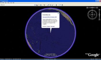
Click to enlarge
This one didn't make it to outerspace.
The future is process, not a destination
Bruce Sterling
Everything is ultimately becoming information technology
Ray Kurzweil
Data is the Intel inside
Tim O'Reilly
There is only one machine and the web is its OS
Kevin Kelly
The medium is the message
Marshall McLuhan
