This was November 2006 | « October 2006 | Main | December 2006 »
tobedetermined finds...
Posted on Tuesday, November 28, 2006
- Swedish space art
- web3.0 here we go...and here too.0
- ISU's Space Odyssey Institute to launch at the ISU Summer Session in Beijing
- ISU's 11th Annual International Symposium "Why the Moon?"
- Point to the sky and the SkyScout will tell you what you are looking at
- The SpaceNavigator, a new 3D mouse for virtual globes like Google Earth

NASA moves into virtual worlds
Posted on Thursday, November 23, 2006

NASA is planning on building a virtual world for training and educational purposes. Its slashdotted here, which made it go around the world, like here at HighEarthOrbit, SlashGeo, Second Life News Network (SLNN) and KnowproSE. Daniel Laughlin, a project manager at NASA's Learning Technologies Office recently gave a presentation about it at the International Spaceflight Museum in Second Life (via OgleEarth). Here are some flickr images of the Museum.
Satellites, humans, and the Internet of Things
Posted on Monday, November 20, 2006
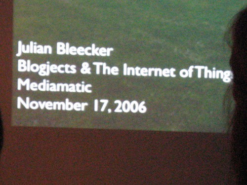
Julian Bleecker was here in Amsterdam for the RFID workshop at Mediamatic. Friday evening he gave a public talk on 'blogjects & the Internet of Things'. Made me think: what are satellites other than blogjects? (more on blogjects at Julian's techkwondo) And what about humans as presented here at Neven Vision? 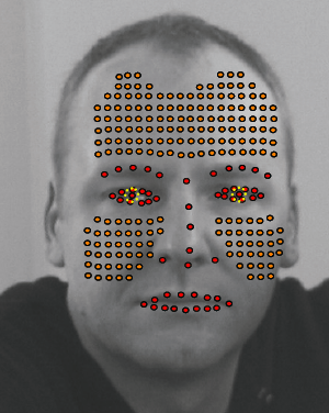
'...scroll over him with your mouse cursors...and...right-click!!'...Indeed, a good point by Julian: what do we learn that is useful from WoW 1008?
'realtime view of the Earth' widget?
Posted on Sunday, November 19, 2006
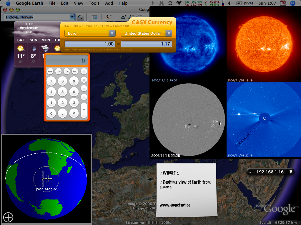
Just in: a demo video of Microsoft Virtual Earth 3D (which comes out blank on my macintosh btw) (via OgleEarth). Where do you want to go today? What about here:
(more at the SOHO website)
online identity: tobedetermined
Posted on Saturday, November 18, 2006
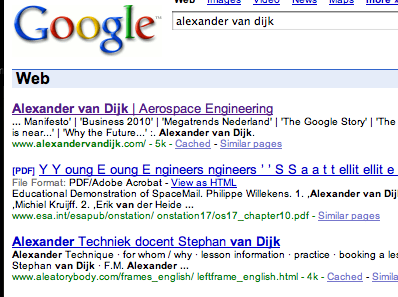
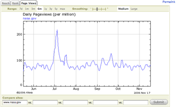
Just found out my name brings up my 'name' website if you do the Google on me...handy...reminds me of an interesting presentation on 'identity2.0'. Something else, how about these webstats for NASA...pretty impressive ;) (via Alexa)
YES2 Google Earth
Posted on Thursday, November 16, 2006
Here is another one of my older posts (May '06) which I managed to bring back from digital oblivion by specifically interrogating The Google about my domain name and looking at the cached pages (search string 'site:tobedetermined xxxx'). Its only good for text though, cause other stuff like images is not cached (thanks for the tip Jurryt).
Recovered post:
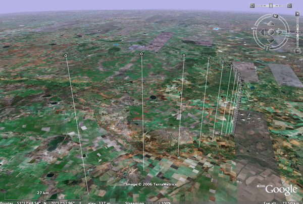
Following up on my suggestion about the resemblance between the 3D GoogleEarth implementation of the TWA flight-800 disaster and the 2.5D visualisation currently available in YES2's Re-Entry Simulator Tool (REST), Marco Stelzer of the YES2 team at ESTEC has done a great(!) job implementing a REST2GoogleEarth output file option in REST.
The REST simulator, which is part of the larger YES2 mission simulator YESSim, is currently under development for ESA's 2nd Young Engineers' Satellite in order to study and control the landing of the YES2 'Fotino' re-entry capsule. The educational YES2 mission is designed to return a small capsule from space to the Earth using a 30 km long tether. Its launch is currently sheduled for October next year from the Russian launch base Baikonur onboard the Foton M3 spacecraft.
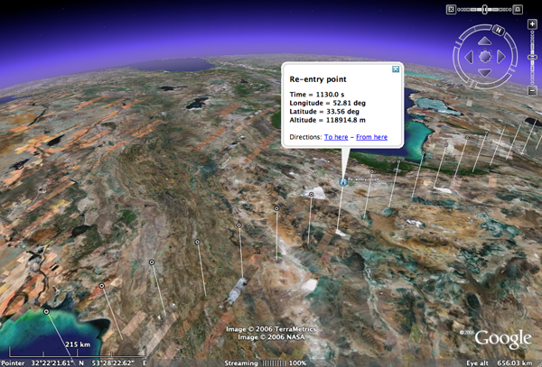
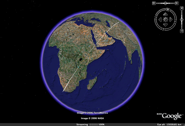
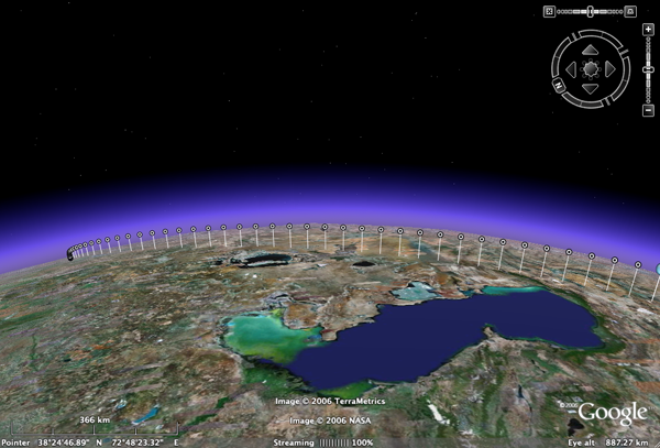
One of the REST2GoogleEarth output files developed by Marco provides an elegant display of the re-entry trajectory as calculated by REST, starting in this case from an initial altitude of ~253 km. Clicking on one of the dots brings up the longitude, latitude, and altitude of the capsule at that particular time in the re-entry (Directions: To here - From here ;) ). In this simulation, the time from start at 253 km to landing of the capsule in Kazachstan takes ~30 minutes. Its not so visible in this particular simulation, but I remember from an earlier one that the influence of the wind (through implemented wind models) on the final stage of descent comes out very nice in the GE visualisation.
In another section of the simulation tool, this 2nd REST2GoogleEarth output file shows the outcome of a monte-carlo simulation of the proposed landing site of the capsule, where each little dot represents a calculated landing point of the capsule. If you zoom out, you start seeing the landing ellipse of the Fotino capsule, representing the 3-sigma chance distribution of the actual landing position of Fotino.
For more on YES2, see their YES2 website (update: which is currently down I believe after having been hacked and them not having the time to bother with a website while building a satellite...). Once its back on, here is a short movie I shot & edited back in 2003 called YES2 meets...Michiel Kruijff with a brief introduction to the YESSim simulator.
ESA teams with Google Earth
Posted on Thursday, November 16, 2006
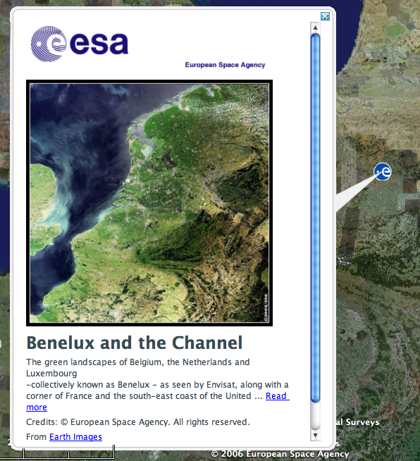
A couple of days after Frank Taylor from Google Earth Blog first noticed the addition of ESA imagery as a layer to Google Earth, ESA comes with a webstory. Nice to see that it gets around, like here, here and here. Btw, Frank makes a good point in stating that he is a bit dissapointed to see that the images are not directly overlayed on Google Earth but instead appear in a pop up window with a link to the image on the ESA web. Room for future developments i'd say ;)
tobedetermined finds...a Google data center
Posted on Tuesday, November 14, 2006
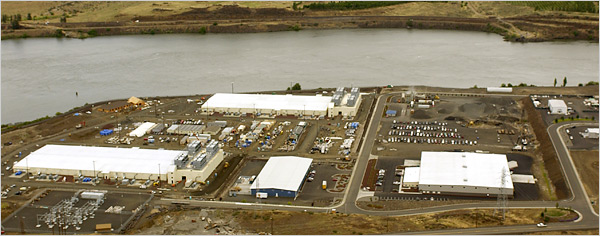
I'll sometimes bring back an image/video which was in one of my earlier posts I lost when my blog (March-July 06) was accidentally erased from the server while over at the ISU Summer Session Programme 2006 in Strasbourg. This one is from an earlier article in the NY times.
citizen journalism
Posted on Tuesday, November 14, 2006
A word I picked up recently is 'citizen journalism'. Its a meme in creation...lets have a look at the steady rise of search results on 'citizen journalism' in Google.
Ministry of transport
Posted on Tuesday, November 14, 2006
Its not related to the theme of this blog, or maybe in the way it looks very second life while being actually first life, a ministry in our 'outer space'...The merger of outer space and the digital space might be a copernican revolution in the making. A flip in perspective, instead of a merger (what would that do to the relation between outer space and our daily lifes here on Earth?) (via we-make-money-not-art).
Another way things might go instead of merge, is the subject of this blog: The end of cyberspace (with the excellent slogan 'Goodbye virtual world. Hello new world')
Pale blue dot update
Posted on Sunday, November 12, 2006
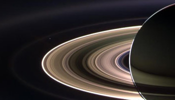
The little white pixel just above the rings of Saturn is...yep...the Earth. Here is the original Pale blue dot. More about this image at Saturn daily.
a recent find
Posted on Thursday, November 2, 2006
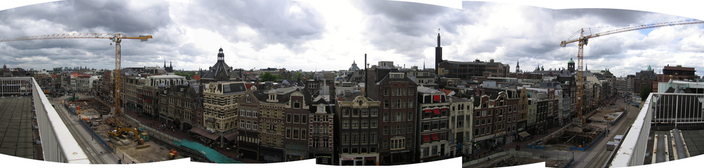
Doing a google check-up, I just came across this panorama which was taken from my balcony on the Rokin here in Amsterdam. Julian Bleecker posted this image on flickr.
Google: you tube
Posted on Wednesday, November 1, 2006
An excellent post on recent developments at YouTube by John Battelle.
And its getting better. Here is a related article that I found in the comments to above blog post.
The future is process, not a destination
Bruce Sterling
Everything is ultimately becoming information technology
Ray Kurzweil
Data is the Intel inside
Tim O'Reilly
There is only one machine and the web is its OS
Kevin Kelly
The medium is the message
Marshall McLuhan